
Massive Tornado Spotted West of Littlefield, Texas — Live Coverage Underway!
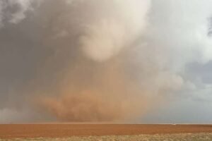
A large and potentially dangerous tornado has been confirmed west of Littlefield, Texas, prompting immediate warnings and live emergency coverage from local and national outlets. Storm chasers and meteorologists are tracking the tornado in real time, reporting intense rotation, debris, and an ominous funnel cloud that has already touched down in open fields.
The tornado was first sighted around 5:15 PM local time, rapidly forming from a supercell thunderstorm that had been building strength throughout the afternoon. The National Weather Service issued a tornado warning shortly after, urging residents in the path to seek shelter immediately. Sirens have been reported in the town of Littlefield and surrounding rural areas.
Weather experts are calling this one of the strongest storms of the season. Video footage captured by storm chasers shows a large, wedge-shaped tornado churning across farmland, kicking up debris and reducing visibility in the area. There is no immediate confirmation of damage or injuries, but emergency crews are on standby.
Lamb County officials have activated their severe weather protocols and are coordinating with state emergency services. Residents are being advised to remain in secure shelters until the storm system passes.
Live coverage is currently ongoing across local news stations, YouTube storm tracker channels, and social media platforms. Meteorologists continue to analyze radar data to determine the storm’s path, intensity, and duration. With conditions still volatile, there is a risk of additional tornadoes forming in the region.
This is a developing situation. Please stay tuned to official weather sources, including the National Weather Service and local authorities, for real-time updates and safety instructions. If you are in the warning area, take shelter now. Your safety is the top priority.